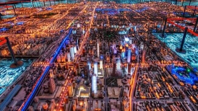
The 10 Most Breathtaking Handmade City Models

Just as the Gutenberg printing press revolutionized the mass production of literature, 3D printing technology transformed the art of landscape and city modeling.

Drastically reducing the time it takes to build intricately detailed and precise models, 3D printing coupled with GPS data has ushered in a veritable golden age of modeling.     

Prior to the advent of 3D printing and unaided by lidar technology, the process of mapping a city alone required hundreds of hours.

And just as the scribes who meticulously transcribed the written word by hand, the craftsmen who built models by hand deserve recognition as the pioneers who paved the way for today’s 3D printing modelers.

Their creativity, uncompromising attention to detail, and above all, dedication to their art, laid the groundwork for today’s explosion in 3D printing.     

In honor of these early modeling masters, we are sharing the 10 most impressive handmade city models from around the world.

1. Berlin

Berlin.jpg

A mere three decades ago, Berlin was a divided city, with its eastern half under the yoke of the Soviet Union.

As the city prepared for imminent reunification following the fall of the Berlin Wall, city planners constructed a massive 1:500 scale model of Berlin’s historic center to facilitate the planning of a cohesive Berlin.

Housed in the Berlin Senate Department for Urban Development and Housing, the model has been updated to reflect post 1991 construction projects, with pre-1991 buildings painted white and newer structures in natural wood color.     

2. Tokyo

Tokyo.jpg

To construct this 1:1000 scale model of Minato-ku—a ward in Tokyo—designers photographed each building by helicopter and car. No wonder the process took 14 months!

Completed in 2009,  the model was used to show sites for Tokyo’s (eventually unsuccessful) bid for the 2012 Olympics.

3. Beijing  

Beijing.jpg

The Beijing Planning Exhibition Hall houses a 1:750 model of Beijing’s metropolitan area, completed in 2004. One hundred fifty workers spent over a year constructing this breathtaking work of art.  

4. Moscow

Moscow.jpg

A 1:500 scale model of central Moscow is displayed at Dom Na Breskoy Center for Architecture and Construction.

Moscow’s city architect Mikhail Posokhin spearheaded this massive project in 1968, overseeing its completion in 1986.

Updated after 1998 to reflect the city’s new construction, the model is centered on Moscow’s iconic Red Square.     

5. Paris

Paris.jpg

Dubbed “Le Petit Paris”, this magnificent 1:130 scale model of Paris took 18,000 hours to complete!

Built from 100% recycled material like concrete blocks and even baby food jars, the extraordinary feat of craftsmanship completed in 2002 by Gerald Brion is located in his garden in Vaissac, South France.

6. New York

New York.jpg

It took more than 100 workers to build this 1:1200 model of the Big Apple.

Featuring 895,000 individual structures, the “Panorama of New York”  was constructed for the 1964 World’s Fair and is currently located at the Queen’s Museum. 

7. London

London.jpg

The family-owned model making company Pipers Model Makers designed and built this 1:1500 model of central London in 2008.

Requiring 5,000 hours to complete, the model covers 39 square feet inside London’s Building Centre—a educational space for architectural studies.  

8. Rome

Rome.jpg

Commissioned by the notorious Italian dictator Benito Mussolini in 1933, this 1:240 scale model of ancient Rome depicts the city as it looked in the 4th Century AD.

The mastermind behind this epic creation, Italo Gismondi, completed this model 35 years later. Visitors can view it at the Museum of Roman Civilization.  

9. Shanghai

Shanghai.jpg

Completed in 2000, this 1:500 scale model of Shanghai covers an astounding 5,200 square feet inside the Shanghai Urban Planning Exhibition Center, making it the largest model on our list.

In a testament to the model’s impressive attention to detail, it includes every structure in the ultra-dense, urban city.    

10. Quebec

Quebec.jpg

To round out our list of legendary miniatures, it’s fitting to profile one of the earliest examples of the art of city modeling.

A 1:300 scale model of Quebec can be found in Quebec’s Artillery Park.

Constructed in 1806 by two members of the Corps of Royal Military Surveyors Draftsmen, it was sent to England in 1810 to spotlight the city’s inadequate defensive infrastructure.

In 1908, it was returned to Quebec in time for the city’s 300th anniversary.     

__

Isaac Newton once mused that he can see so far because he stands on the shoulders of giants.

Likewise, those of us who print 3D city models owe a huge debt of gratitude to the ‘giants’ whose vision and dedication laid the foundation for modern modeling techniques.

Thanks to them and to the advances in lidar and 3D printing technology, we are able to construct exquisitely detailed and precise models of virtually any city or landscape.

You can browse MiniCityArt’s complete collection of 3D printed city models here

For more images of 3D printed maps, cities and other landscapes, check out Terramano’s excellent repository for 3d maps around the world.

What is Scale?

Like most mathematical things, scale is a simple concept wrapped in a specific word with deep ramifications. As far as miniatures are concerned, scale is simply the ratio of lengths between two representations of a thing. If MiniCityArt made a print of a city block as big as the real city block, we’d call that 1:1 scale. Obviously, we’re not going to make a print that large! It’s a lot cheaper to build a 1:1 building out of concrete and steel than 3D printing filament, and a lot faster! Nevertheless, this begins our visual illustrations of scale and how it relates to 3D printing cities.

We would love to be able to print entire cities and make them affordable, but cities are big. Our perception of cities as being dominated by immense tall buildings ignores the fact that less than a few percent of the area of most cities contains those tall buildings. And the height of those buildings is minuscule in relation to the width of their host city. Let’s take Detroit, a city I’m very familiar with. Detroit is about 18 by 11 miles in size, noting that 11 miles is 58080 feet. A nice 12” (1 foot) print of the city would need to be 1:58080 scale to contain just the North-South extent of the city (1 foot on the model represents 58080 feet in real life). The tallest building in Detroit, the Renaissance Center, stands 727 feet tall. On our hypothetical model, that building would be only 0.15” tall (12 inches times 727 feet divided by 58080 scale ratio), or 3.8 mm. Would you even notice it?

So, instead of trying to print the entire city, MiniCityArt models focus on the downtown - where all the landmark buildings typically are! The first photograph below is a 6”x6” print of downtown Detroit at 1:20000 scale. There’s the RenCen on the right, adjacent to the river. You can see that there’s a little detail in the buildings, and smaller buildings and patches of trees are visible as clumps, but nothing smaller than that is apparent. And we’re covering nearly four square miles (6” is one-half foot, times 20000 is 10000 feet, which is about 2 miles) of Detroit’s nearly 140 square miles. A model of the whole city at this scale would measure about 5 by 3 feet.

Downtown Detroit at 1:20000 scale

Downtown Detroit at 1:20000 scale

Our 8” models are in 1:10000 scale, so one inch on the model represents 10000 inches in the real world (about 833 feet). The Renaissance Center (727 feet, remember) is a little less than that 833 feet, so we would expect the Renaissance Center in a 3D print of Detroit at 1:10000 scale to be a little less than one inch tall. Well, the image below shows one quarter of the area of the print above, and here at 1:10000 scale. So this is about one square mile, and now we can start to see air handling units on the roofs of buildings, more details in the buildings, some bridges, and even some individual trees and monuments and public artwork.

Downtown Detroit at 1:10000 scale

Downtown Detroit at 1:10000 scale

Let’s go even larger. Well - the print will stay the same 6”x6”, but the scale will change to 1:5000. This is the scale that we use for our 24”x24” 3D printed cities. Here’s where things get really interesting. Now we can see individual buses and even cars. Some light poles show up as thin sticks. Larger works of public art now have shapes, and even more architectural details are visible, including thin spires, walls, and fences.

Downtown Detroit at 1:5000 scale, centered on Hart Plaza

Downtown Detroit at 1:5000 scale, centered on Hart Plaza

We’re not done yet! The data that MiniCityArt uses is called LiDAR, which stands for Light Detection And Ranging. Airplanes fly overhead and project a swath of small laser pulses down at the ground. If a pulse hits anything which causes the light to bounce or reflect back up to a detector on the airplane, a record is made of the direction and time that it took the pulse to return. With precise knowledge of where the airplane is and of the speed of light, the device calculates a position for where that reflection occurred. The collection of those positions is a “point cloud”, and only contains the position of the “hits”, not what was hit. It could have been a patch of pavement, a blade of grass, a foamy crest of a water wave, or a person’s hat. And there are millions of these “points” per square mile, sometimes tens of millions.

This abundance of data gives us the ability to 3D print cities with incredible levels of detail. The final image below is the Renaissance Center and surrounding buildings printed at 1:2500 scale. This is the scale that we print our largest models at: anything over four feet in size. At this scale, every car is present. Most light and electrical poles, all fences, all trees and most shrubs. Every bus, truck, and boat. Recliners on urban roof decks are even here. This is about the limit of our data. At this scale, we could print the entirety of Detroit, but the full model would measure 38 by 23 feet (18 by 11 miles times 5280 feet per mile divided by 2500), and would take 6 years to print on a single 3D printer.

That sounds like a challenge.

Renaissance Center and nearby parking garages at 1:2500 scale

Renaissance Center and nearby parking garages at 1:2500 scale

You can 3D print all of Boston for free

MiniCityArt just released 3D printable tiles for the entire City of Boston on Thingiverse. Every building, hill, and bridge in Boston appears in these pieces. Head there now and download and print any tiles you want. Original data came from the Boston Planning & Development Agency, but was made 3D printable using code developed here at MiniCityArt HQ in Fort Point.

The city is broken up into 210 square tiles, each 1km square. The geometry is in mm, so if you print them as-is, you will get a 100x100mm (4"x4") tile at 1:10000 scale. At this scale, all of Boston would be 6 feet high and 7.5 feet wide. If you print it 200% size, the model will be 1:5000 scale and each tile will measure 200x200mm (8"x8"). If you printed every tile, the resulting map would be 12.5 feet high and 15 feet wide!

IMG_0581.jpg

Tile L-5, containing a corner of Boston Common, the State Capitol, Government Center and City Hall, and Downtown Crossing

We’re busy printing every tile at 1:10000 scale to create the first 3D printed map of the entire City of Boston. Photos of our progress appear below. If your school or gallery or civic building would like to show the finished piece, please contact us!

Note that these tiles are not quite like MiniCityArt’s regular products. The data used to generate these tiles contains only buildings, bridges, and land, while MiniCity models use much larger and more detailed datasets containing every tree, car, bus, light post, and detail in a city, including all the air handling units on the tops of buildings, all of the highways, bridges, and infrastructure, boats in marinas, etc.

This project would not have happened without the freely-available data from the Boston Planning & Development Agency (provided without warranty) and support from Artists For Humanity. The work to prepare and post these tiles was done by our new data intern Suleiman Hussein.

Mark S.
Founder, MiniCityArt

Remarkably, this is only one third of the City of Boston!

Remarkably, this is only one third of the City of Boston!

This is the tile grid used for our converted models - note that the new tile grid at the BPDA is different